FAIR-EASE, AN AMBITIOUS EUROPEAN PROJECT TO OBSERVE VOLCANIC ERUPTIONS
26 partners coordinated by the CNRS met on September 20 for the first time in Paris, France, for the FAIR-EASE Kick-off. They join conferences and workshops aimed at the integrated use of environmental data through cross-cutting discovery and data access services. Three use cases were presented to contribute to the technical and scientific requirements of the European FAIR-EASE project.
In this context, a case study will be conducted to better understand volcanic activity around the world. Marie Boichu, CNRS researcher at the Laboratory of Atmospheric Optics (LOA) at the University of Lille, works on volcanic emissions to understand the volcanoes and the impact of volcanic eruptions on the atmosphere and the environment. She coordinates the “Volcano Space Observatory” pilot project as part of the FAIR-EASE project.
In coordination with the Aeris and Form@ter hubs of the Data-Terra research infrastructure, this case study around the volcanoes activities is multidisciplinary because it aims to bring together the Atmospheric and Solid Earth Sciences communities to enable them to jointly analyze a large set of remote sensing observations. These observations are mainly collected by Earth observation satellites, but also include ground data collected by large networks of geophysical and geochemical instruments.
Most of the active volcanoes in the world are isolated, difficult to access and most often not instrumented. When the volcano is monitored on the ground, major volcanic eruptions can also cause destruction of instruments on the ground or make direct observation perilous. Spatial imagery is then a valuable tool to help complete the understanding of the activity. Observations on volcanoes provided by the Terre Solide community are made using radar and optical imagery. Data from the Atmospheric Sciences community provide a set of information on the spatio-temporal distribution and physico-chemical properties of gases and particles, from satellites in low orbits.
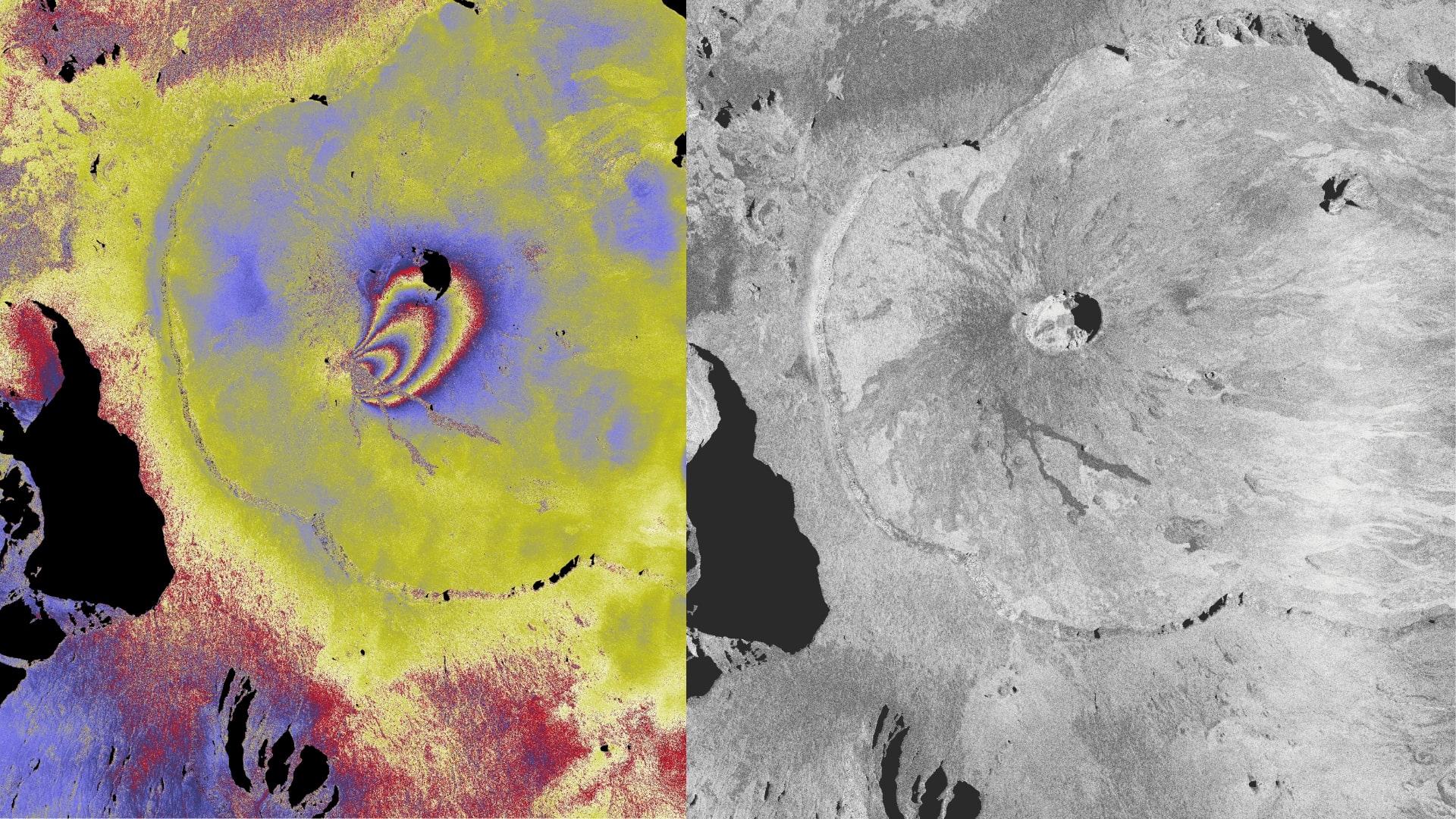
A concrete example in recent weeks with the eruption of Piton de la Fournaise on September 19, 2022.
For 2 weeks, the eruption of the Piton de la Fournaise volcano on Reunion Island fed lava flows and released substantial amounts of gas into the atmosphere. The ISDeform Observation Service has produced an interferogram on which the movements of the ground are clearly visible. These make it possible to estimate the volume of magma injected under the eruptive fissure. (cf. see the cover image).
See more on the Form@ter website
As lava flows to the surface, volcanic gases are emitted into the atmosphere. The TROPOMI sensor on the Sentinel 5P satellite of the Copernicus program provides daily images of the spatial distribution of sulfur dioxide (SO2). This information is useful for monitoring the evolution of effusive activity and anticipating episodes of air pollution of volcanic origin. It is accessible on the VolcPlume portal, administered by the Aeris pole of DATA TERRA.
Access the latest volcano activity bulletins on the IPGP website
Images from very high resolution radar satellites, such as the commercial Capella Space constellation, also provide daily very detailed images of the fissures and the cone feeding the lava flows.
After 2 weeks, the eruption of 🌋 volcano #pitondelafournaise (La Réunion island) is still in progress. Here, @capellaspace radar satellites 🛰️ provide daily sub-metric images of the fissure and cone feeding the lava flows. Imagery: 2022-Oct-02, 11:30 UTC. 1/N pic.twitter.com/iZZo7pwAGS
— Raphael Grandin (@RaphaelGrandin) October 3, 2022
“The eruption that started on September 19, 2022 around 07:48 local time stopped today, October 5, 2022, around 10:10 local time (6:10 UTC) following a sudden stop of the eruptive tremor.”
Piton de la Fournaise Volcanological Observatory
The Volcplume web observation platform, developed by the Atmospheric Optics Laboratory (LOA) in collaboration with the AERIS/ICARE Data and Services Center, both in France, makes it possible to monitor volcanic emissions and plumes thanks to a coupling of data from satellites and from ground measurement stations network. The scientists were thus able to describe the evolution of the sulfur dioxide (SO2) degassing activity associated with the effusive activity of the Piton de La Fournaise.